Thursday 23 May 2013

Books on the River Thames

The Best Books on the Thames

Ten favourite books on the Thames River, both fiction and non fiction, (courtesy of Catherine Ames who is also leading a group of Thames walkers this year).

Saturday 11 May 2013

The source to Cricklade

The source of the Thames to Cricklade - May 7th - Anne, Ellen and Theresa
Length 22 km (14 miles)

Finally the weather has warmed a little and the days are longer.We have therefore  taken a giant leap from our city walks (literally) and last  Tuesday Ellen, Theresa and Anne travelled out to the source of the Thames in rural Gloucester and our group will now walk back towards London over the next few months. 

Our walk began in Kemble, about a mile from the source of the Thames. This point is generally recognised as the source of the river Thames although it was just a dry dip in a field of cows, marked by the signpost, a stone marker and a small group of pebbles marking the spring beneath an ancient elm tree.
Our walk truly begins here and as we doubled back towards Kemble, the early signs of the river began to appear. 


The true beginning of our journey
Theresa and Anne at the source of the Thames


Ellen and Theresa at the source.

The river begins its journey
The Thames just near Kemble

The remains of an old stone crossing near Kemble

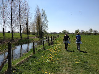
Through the Gloucestershire countryside


The weather was fantastic - about 23 and sunny. We walked through fields, past farms and past the cottages of the tiny hamlet of Ewen. Our walk continued through the Cotswald Water Park, a huge area of land transformed from gravel pit workings into a series of about 150 lakes, managed by a trust to ensure wildlife and biodiversity of the lakes are protected, while at the same time offering a range of water based recreational activities. We disturbed what looked like a small camp of soldiers fishing and enjoying the peace of the area.

Ashton Keynes provided us with a very nice pub for lunch - the White Hart. The village was beautiful with picture perfect homes of Cotswald stone, beautiful gardens, and a series of channels of water, flanked by daffodils, lining the road into the village.

Our afternoon walk continued through more lakes and ended at North Meadow Nature Reserve on the edge of Cricklade. This meadow protects one of the finest remaining examples of ancient lowland hay meadows in Europe. However, I suspect that fatigue, combined with a need to catch a train asap from Swindon and the very late arrival of spring this year , meant that many of the species of wildflowers to be seen here, eluded us!

A few bluebells valiantly declare spring.

Theresa and Ellen


Contented Kemble cows!
In Cricklade at the end of our walk


We arrived in Cricklade to find our taxi, booked while walking, waiting to whisk us to Swindon in time for a train to London and, for Ellen, a night at the theatre!


Destination reached. Length of walk approximately 22 km.


Tuesday 9 April 2013

Chertsey to Windsor

Chertsey to Windsor - 5th April
Anne, Ellen and Jan
approximately 20km

We are outside the M25!  This walk was again completed in cold and windy conditions. No spring yet and no spring flowers yet either.

From Chertsey the path took us past Chertsey Lock and under the M3 motorway, through Laleham Park and past the small town of Laleham, where there is thought to have been a 1st century Roman marching camp. Laleham House was the seat of the Lukan family. (The 7th Earl of Lukan disappeared in 1974 after being accused of murdering the  family nanny.)
Jan and Ellen just after Chertsey Bridge
We walked on to Staines (a river crossing since Roman times) and crossed the bridge to the south side of the Thames and continued on to Runnymeade, the site of the signing of the Magna Carta nearly 800 years ago. After another 8km, we stopped for lunch in Datchet, a modern commuter village but charming  and a welcome stop after a long morning. 


Jan and Anne in Windsor at the end of the walk 

Our walk continued into Windsor where we caught the train back into London. A long day's walk!


Hampton Court to Chertsey

Hampton Court to Chertsey-18th March
 Anne, Jan, Theresa, Sally, Wendy
approximately 13km

We have now completed the 'London' section of the Thames Path and as spring continues to evade us, our walks continue in cold, windy and wintery conditions. We are now walking east out of London and the river is becoming more rural.
 From Hampton Court station it was not long before the path became quite rural. Small islands dotted the river, each with their own local community.

 A more rural river 

Above, Garricks temple, the small domed building, was built in 1756 by the actor/manager David Garrick to celebrate the life of Shakespeare
 Pleasure boats lined the river and occasionally, we could see great concrete blocks, remains of London's anti-tank defences.

 A lock with a lovely hotel and homes on the opposite bank.

 Swan feeding areas attract waterfowl and pigeons as well as swans. 


The path leads to Walton on Thames. Unfortunately, the rare ferry crossing across the river and into Shepparton was not running and we detoured across the Walton Bridge and into Shepperton.

Lunch stop was the Thames Court pub on the river in Shepperton. 

After lunch, we continued walking, passing a colourful river community of boats - the Rye Peck Meadow Moorings and through Dumsey Meadows (one of the few remaining traditional watermeadows on the river) and across the bridge into Chertsey, which has become a large commuter town and is one of the oldest recorded towns in the country.

Hampton Court to Kew Bridge


Hampton Court to Kew Bridge - 4 February 2013 
Anne, Ellen, Jan, Theresa and Sally


Our walks have been planned to take into account the weather in England during winter and spring. One of our first walks was this walk from Hampton Court to Kew Bridge and as you can see, the weather was superb. Since then, we have not been so lucky.

We walked from Hampton Court station, past Hampton Court, built originally for Cardinal Wolsey, one of Henry VIII's chief advisors, and then given by Wolsey to Henry. Built about 1514 it drew on Italian Renaissance principles alongside more traditional late Gothic and was enlarged by Henry with the addition of the Great Hall, a tennis court and wonderful gardens.


Anne, Ellen, Jan and Theresa with Hampton Court Bridge in the background


This walk took us around Hampton Court Park and along the northern bank of the Thames.
There are lots of small islands here. The word 'ait' a contraction of 'eyot', is a Middle English term meaning 'little island'.

We passed Kingston , crossing the bridge to the south side of the Thames. A bridge has been in existence here since at least the 12th century. Today's bridge was built in 1828.
After a brief stop at Teddington Lock, the point at which the tidal river stops, we continued along the southern bank of the Thames, passing the Ham Lands nature reserve with glimpses it towards Ham House and ahead of us, the  Star and Garter Home on Richmond Hill. originally built for seriously injured servicemen after World War One.
As we walked along the riverbank and into Richmond we could see wonderful 18th century homes overlooking the river. We continued into Richmond and had lunch at the White Swan pub on the waterfront just after Richmond Bridge.
The walk continued along the southern bank of the Thames, past the Old Deer Park, past Kew Gardens (hardly visible behind tall walls and foliage) and on to Kew Bridge where our walk ended.

Kew Bridge to Tower Bridge


Battersea Bridge to Tower Bridge - 24 February 2013
How familiar we all are with this section of the Thames. It is our constant companion and in fact, almost our  backyard. Most Australians have a great affinity for water and most of us here in London, love to be beside the water. The coast of England has its charms, but our immediate need to be beside water can be met by wandering along the Thames. The vista changes daily.
Here we see the Houses of Parliament at Westminster from the Lambeth or south side of the Thames, just near Lambeth Palace, the home of the Archbishop of Canterbury.

Houses of Parliament from Lambeth Walk
Further west, the view across the Thames from Battersea Bridge, looking towards World's End Chelsea.

The Thames from Battersea Bridge - late winter afternoon light
This section of the Thames was not one we walked as a group. However, all of us have walked it several times during our time in London.

Kew Bridge to Battersea Bridge - 11 February 2013

This section of our walk provided us with several challenges - amongst them snow, probably sub zero temperatures and mud. but it is also one of the most beautiful sections of the Thames Path. For an urban walk it is quite countrified, with unmade paths (mud!) trees and flowering shrubs.
Chiswick Bridge is an elegant structure, mad of concrete but faced with Portland stone and built in an 18th century style.
The views across the river from the south side are also interesting - Dukes Meadow sporting complex and the Hurlingham Club in Fullham. As we approached Barnes Bridge we passed the White Hart pub, one of my favourites. On a summer day you can cycle to this pub and sit right on the riverside with a drink and watch the rowers passing up and down the river and the joggers passing up and down the path. Continuing on, we passed St Paul's School, one of the country's most elite and then on to Hammersmith Bridge, a green suspension bridge, built in 1887 and designed by engineer Joseph Bazalgette.

Hammersmith Bridge built 1887 by Joseph Bazalgette.
The most ornate bridge on the Thames.

Further on still lies the Harrod's Furniture Depository, built in a Baroque style to house furniture that was too big for the store itself (now flats).

The section from Mortlake to Putney is the stretch of water famous for the annual Oxford versus Cambridge boat race which has taken place since 1829, usually in April or May.

Near Putney Bridge looking west
We had a much needed break from the weather at Carluccio's in Putney.

From Putney Bridge we continued through Wandsworth Park, past beautiful painted barges and some very large modern houseboats near the modern Riverside Quarter - a new development with an open plaza and a couple of restaurants.

The path continues on with a few diversions off the river and around the Battersea heliport and past the churchyard of the lovely St. Mary's Battersea, built in 1775 and incorporating several 17th century monuments from its medieval predecessor.
St. Mary's Battersea (1775)
We ended our walk at Battersea Bridge, another bridge designed by Joseph Bazalgette and constructed in 1885.


Thursday 21 March 2013

A Walk on the north side - Tower Bridge to Greenwich


Tower Bridge to Greenwich - 18 February 2013 (6.5 miles,10.4km) 
Anne, Ellen, Kerry, Theresa, Jan and Sally

This was a diverse and interesting walk along the north bank of the Thames. The walk started in the area of the Roman settlement Londinium, still evident in remains of walls. The docks along the bank were heavily bombed during WW2 and many of the warehouses destroyed, but redevelopment has followed the same scale and layout and allowed for attractive marinas (below) quite a surprise so close to the city. 
The Shard from the north bank near Wapping


Marina near Tower Bridge - north bank
We continued down Wapping High Street past a gorgeous row of Georgian houses built for dock officials in the early 19th century.

The old Wapping Hydraulic Power Station, now an Arts Centre known as the Wapping Project was closed but worth noting for a return visit - perhaps for a meal. You can find more information about the Wapping Project in an article from the Guardian here.
Our walk continued through Limehouse where, as the name suggests lime kilns were once built and where for hundreds of years a shipbuilding and kitting out area functioned. Eventually we arrived at Canary Wharf for a coffee break amongst the 'suits' and then continued walking south to Island Gardens at the southern tip of the Isle of Dogs where we were suddenly  confronted by the new-classical buildings of Greenwich across the river. A round red brick building provided an entrance to a bleak winding staircase leading to the tunnel under the Thames and out again in Greenwich.


Sunday 17 March 2013

Walking east from Greenwich


Woolwich Arsenal to Crayford Ness - January 28 2013 (8.5 miles, 13.7km) Wendy and Anne

 Salt marsh near Crayford Ness - near the mouth of the Thames

How interesting to head out to the Thames east of the city of London. A place of contrasts as shown by the photos above and below. The last time I saw a group of Antony Gormley's figures, they were in Australia. If you haven't seen these figures in the outback, click the above link for a treat.

Meanwhile, back in London, more Gormley figures at Woolwich Arsenal (and Wendy).

Cast iron humanoids by Antony Gormley 

 Royal Arsenal - Woolwich
First established 1621

Arsenal Woolwich used to be the home of the Arsenal Football Club before they moved to north London. 

During WW1 the Royal Arsenal covered 1300 acres and employed about 80,000 people. It suffered heavy bombing during WW2 and the ordnance factories closed in 1967. There is an interesting collection of fine buildings, some renovated, including a museum and a great bar/restaurant.


Greenwich to Woolwich Arsenal - Monday 11 March 2013 (5.75 miles 9.25km) Anne and Ellen

We began this walk in Greenwich with a bitingly cold head wind and probably a temperature of  -3. However, the sun came out and the weather was kind. Again, a walk of contrasts: from Sir Christopher Wren's Royal Naval College to the Millenium Dome or 02 stadium, with views across to Canary Wharf.


Ellen with O2 and Canary Wharf in the background
Sculpture at 02 (courtesy Ellen)
The Thames Barrier is designed to cope with sea level rises until 2030 and is a major part of the effort to protect London from flooding. It looks great and does not pose any height restrictions for shipping. There were evidently 41 different proposals for the design of the barrier. I am glad they chose this one!
Thames Barrier - operating since 1982 and raised  more than 110 times.

Thursday 14 March 2013

Interactive Map of the Thames Path

For an fantastic interactive map of the Thames Path and an overview of the Thames Path route click here and then click on the link for the photographic interactive map.

Wednesday 13 March 2013

Welcome to our blog!


Welcome to our blog! A record of our 2013 wanderings along the Thames path.

We are a group of expatriate women living in London and this year we are walking the Thames Path from the mouth, east of the city of London, to the source in rural Gloucestershire nearly 200 miles upstream.
Our guide is The National Trail Guide which you can find here and here and here. You will find photographs, accommodation guides, maps etc. All you need to begin walking.

It's cold. Very cold. So our winter walks have concentrated on the path within London - from Hampton Court in the west to Crayford Ness in the east, a total of 50 miles (80km). This has taken us through 2000 years of human history, past many world famous buildings, past (and over) 23 bridges, past (and through) tunnels under the river and past ferries crossing the river as they have done for thousands of years.
We thought that with the cold, the wind and the snow, these city walks would give us greater flexibility to seek the warmth and comfort of cafes and pubs, for respite from the elements. This has proved the case. But we have not yet abandoned our journey and we have always reached our goal for each walk.

'We are here on the planet only once, and might as well get a feel for the place.'